![[back]](images/Larrow02.gif)
Gibbes Green
Gibbes Green is an area north of Davis College and east of the Horseshoe--although it was formerly a considerably larger expanse that spread north and west of the area we now call by this name. For years it was an open space between the South Carolina College and the city as they grew towards each other. It is hard to believe that this lovely area was at the center of contention from the mid to late 19th Century into the 20th. This contention, born during a period of population growth in Columbia, was affected by events of the Civil War and also, in turn, affected buildings as the campus expanded. Curiously, the layout of the streets around the University as we know them today was also influenced.
The
Green was named after Major Wade Hampton Gibbes (1837-1903) as
Daniel Walker Hollis reports in his 1956 history of the
University. Hollis reports that Gibbes:
...owned much of the property east of what is now Pickens Street, consisted of three squares of land bounded on the north by Pendleton Street, on the east by Pickens, on the south by Devine, and on the west by Bull. All this area was acquired by the College through an act of the legislature in 1833, with the exception of the western half of the middle square bounded by College, Pickens, Greene5, and Bull, which was purchased for $400 from the estate of Malachi Howell in 1838. The great fire of 1865 had destroyed the courthouse records, however, and private citizens claimed the property on the basis that it was abandoned land which the University did not own.6
The
matter simmered for a number of years as the city and the College
continued to grow towards each other. There were several
milestones:
1892--An attempt was made to float a $50,000
bond issue to bring Winthrop College to Columbia. Meanwhile
another group attempted to take some of this land away from what
was to become the University. President Woodward is quoted as
having told the trustees: "...do not sacrifice a foot."7
1902--"...private citizens presented a claim to the old Howell property..."8
1904--"...President Sloan had the Green laid out in golf links." He stated:
The sale of that part of the College property...cannot now be urged on account of non-occupancy.
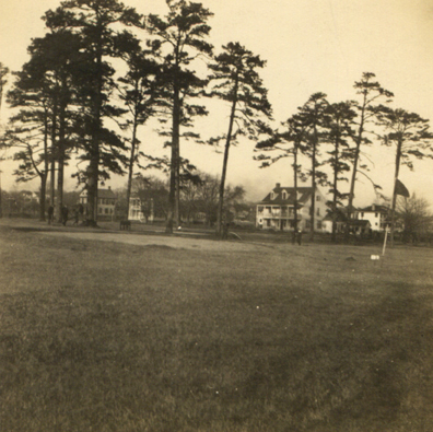
This undated photograph (172K) of Gibbes Green has a golf flag on the right so it must have been taken about this time.
The State editorialized:
It would be, in any and every view, a grave error to carry the University group, at this time, across Bull Street into the Green....It is not necessary to sacrifice this beautiful open space--almost the only breathing space in the city...9
1908--A bequest from Mrs. Ann Jeter for a new infirmary began a "third period of building activity"10 on campus. A 1908 plan to build on part of the Green led to a compromise and the University's first infirmary was build on the southwest corner of Bull and Greene Streets.
Meanwhile, the University was growing and the Green was prime territory for new buildings. A search of the University's records revealed details of the Howell acquisition.
Armed with this evidence, the trustees determined to build on the Green, but the matter was not finally settled until 1909, when the State Supreme Court ruled in the University's favor.11
A photograph (82K) taken about 1910 shows the recently completed Davis College on the left.
As was mentioned, this contretemps affected traffic in the area as the increasing population led citizens to demand new roads for their convenience.
Hollis
reports that: "At the turn of the century Pickens
Street...came to a dead end at its intersection with
Pendleton." He continues:
Major Gibbes' heirs sold some of the lots in this area, and as population increased, the new residents demanded a right of way to Pendleton Street. The lane they were accustomed to using was on the extreme eastern side of the College property and in 1906 President Sloan recommended that a thirty-foot strip from Pendleton southward to Greene Street be granted the city provided the residents would make no effort to open College Street from Pickens to Bull.12
A few years later property owners between Greene and Devine attempted to continue Pickens southward from Greene Street. As Hollis reports:
After prolonged negotiations, an agreement was reached in 1915 whereby the University deeded the city an additional thirty-foot strip between Greene and Devine, in return for a thirty-foot strip on the north side of Greene Street, from Bull to Pickens. This would have narrowed Greene Street by thirty feet when it reached Bull, but the University's quid pro quo appears to have been lost sight of. Instead, Greene Street, though it offsets at the Bull Street intersection, proceeds eastward at the same width. As a result, the block now occupied by the women's dormitories has been trimmed on both north and east until it measures only 387 by 387 feet, instead of the standard 417 by 417. It thus appears that the University made a most liberal concession regarding Pickens Street, which offsets sharply at Pendleton and proceeds southward for three blocks on what was once exclusively University property.13
So, the fact that records were burned during the Civil War had an effect on the settlement in the area, the expansion of the University, how the streets we use daily developed in the Davis College area, and the building of Davis College.